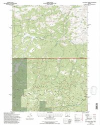
1992 Map of Dutchman Creek
USGS Topo · Published 1997About this map
The Och Oco Mountains dominate this high-desert landscape in central Oregon, where the boundary between Jefferson and Crook counties cuts through the rugged terrain. This area of the Och Oco National Forest is defined by a complex network of springs and drainages, such as Ochillee Spring and Dutchman Creek, which provide vital water sources in an otherwise arid environment. The map reveals the intricate topographic character of the region, from the steep elevations of Cat Mountain to the broad, level stretches of Boxcar Flats and Highland Flat.
Find a feature on this map
33 named features on this map. Tap any name to fly to it.
Don’t see what you’re looking for? This feature index may not catch every label — zoom into the map to look around manually.
Map Details
Editions of this 1992 Dutchman Creek Map
This is the sole edition of this map. No revisions or reprints were ever made.
Other maps of this area

1948 · Ochoco Reservoir
USGS Topo · 1:62,500

1950 · Ochoco Reservoir
USGS Topo · 1:62,500

1955 · Bend
USGS Topo · 1:250,000

1957 · Bend
USGS Topo · 1:250,000

1958 · Bend
USGS Topo · 1:250,000

1962 · Prineville
USGS Topo · 1:62,500

1968 · Horse Heaven Creek
USGS Topo · 1:24,000

1968 · Axehandle Butte
USGS Topo · 1:24,000

1968 · Dutchman Creek
USGS Topo · 1:24,000

1968 · Ashwood
USGS Topo · 1:24,000