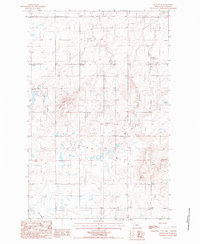
1987 Map of Dutton SE
USGS Topo · Published 1987About this map
Teton Ridge dominates this northern Montana landscape, where the terrain is defined by a series of distinct Alkali Flats and localized depressions. This 1987 provisional survey reveals a specialized economy and infrastructure, notably the industrial presence of multiple Gravel Pit locations and a lengthy Pipeline traversing the sections. The drainage patterns are anchored by Lake Creek at the southern edge, while the broader geography is shaped by the intersection of townships T24N, T25N, and T23N. The map provides a precise look at the land's transition between the elevated ridge and the numerous Alkali Flat pockets that dot the township grid before the turn of the century, serving as a primary reference for those studying the physical evolution and resource extraction history of this part of Teton County.
Find a feature on this map
9 named features on this map. Tap any name to fly to it.
Don’t see what you’re looking for? This feature index may not catch every label — zoom into the map to look around manually.
Map Details
Editions of this 1987 Dutton SE Map
This is the sole edition of this map. No revisions or reprints were ever made.
Other maps of this area

1886 · Great Falls
USGS Topo · 1:250,000

1949 · Timber Coulee
USGS Topo · 1:62,500

1949 · Great Falls
USGS Topo · 1:62,500

1949 · Vaughn
USGS Topo · 1:62,500

1950 · Timber Coulee
USGS Topo · 1:62,500

1950 · Dutton
USGS Topo · 1:62,500

1951 · Great Falls
USGS Topo · 1:62,500

1952 · Vaughn
USGS Topo · 1:62,500

1954 · Great Falls
USGS Topo · 1:250,000

1957 · Great Falls
USGS Topo · 1:250,000