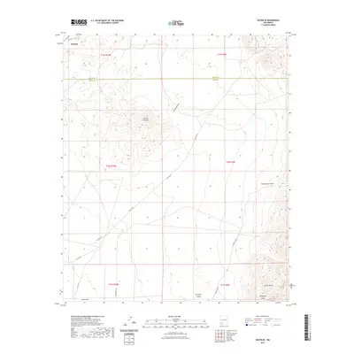
2023 Map of Dwyer SE
USGS Topo · Published 2023About this map
The Mimbres River cuts through the northwest corner of this Luna and Grant county borderlands survey, marking a vital water source in an otherwise arid landscape. Near this waterway sits the settlement of Faywood, positioned just north of the notable peaks of Round Mountain. The topography is defined by the significant rise of the Cookes Range in the southeast, where steep contours give way to drainage features like Montezuma Canyon and Butterfield Draw. This area preserves the path of the historic Butterfield Trl, a corridor of western migration and transport that follows the natural breaks in the terrain. The network of rural routes, including Co RD a012 and Keeler Rd Nw, connects isolated draws such as Cordwood Draw and Porter Draw, illustrating the modern management of these ancient transit routes through the high desert.
Find a feature on this map
20 named features on this map. Tap any name to fly to it.
Don’t see what you’re looking for? This feature index may not catch every label — zoom into the map to look around manually.
Map Details
Editions of this 2023 Dwyer SE Map
This is the sole edition of this map. No revisions or reprints were ever made.
Other maps of this area

1899 · Deming
USGS Topo · 1:125,000

1915 · Deming
USGS Topo · 1:125,000

1955 · Las Cruces
USGS Topo · 1:250,000

1956 · Dwyer
USGS Topo · 1:62,500

1958 · Las Cruces
USGS Topo · 1:250,000

1962 · Lake Valley
USGS Topo · 1:62,500

1964 · Goat Ridge
USGS Topo · 1:24,000
1964 · Spalding
USGS Topo · 1:24,000

1964 · Massacre Peak
USGS Topo · 1:24,000

1982 · Hatch
USGS Topo · 1:100,000