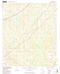
1994 Map of Dyas
USGS Topo · Published 1998About this map
The Perdido River forms the eastern boundary of this mid-1990s landscape, marking the transition from Baldwin County, Alabama, to Florida. The area is characterized by a network of creek bottoms and low ridges, where several small settlements such as Perdido and Dyas are established along the primary rail line. Local history is deeply etched into the terrain through features like the Old Pensacola Road and scattered rural institutions. Genealogical researchers will find value in the specific locations of the Cain Cem, New Providence Ch, and Horseneck Ch. The presence of a Claypit and several named watercourses, including Bushy Creek and Horseneck Creek, illustrates the drainage patterns and resource extraction that defined the local economy before the turn of the 21st century.
Find a feature on this map
17 named features on this map. Tap any name to fly to it.
Don’t see what you’re looking for? This feature index may not catch every label — zoom into the map to look around manually.
Map Details
Editions of this 1994 Dyas Map
This is the sole edition of this map. No revisions or reprints were ever made.
Other maps of this area

1941 · Bay Minette
USGS Topo · 1:62,500

1942 · Perdido
USGS Topo · 1:62,500

1942 · Dyas
USGS Topo · 1:62,500

1943 · Bay Minette
USGS Topo · 1:62,500

1943 · Tensaw
USGS Topo · 1:62,500

1944 · Tensaw
USGS Topo · 1:62,500

1944 · Dyas
USGS Topo · 1:62,500

1944 · Perdido
USGS Topo · 1:62,500

1953 · Andalusia
USGS Topo · 1:250,000

1957 · Andalusia
USGS Topo · 1:250,000