1987 Map of Dyer
USGS Topo · Published 1987About this map
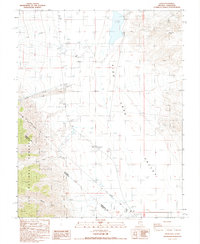
Fish Lake Valley serves as the focal point of this high-desert landscape in the late 1980s, where the small community of Dyer clusters along Highway 264. This settlement serves as a critical agricultural and residential hub, evidenced by the presence of Dyer Sch, a local Cem, and a County Park. To the west, the terrain rises sharply into the Inyo National Forest and toward Brown Ridge, with drainage provided by seasonal flows such as McAfee Creek, Leidy Creek, and Busher Creek. The map records an important historical boundary, the Von Schmidt Line, which cuts across the basin floor. This line, along with the Nevada California border, illustrates the complex surveying history of the region. Irrigation is a primary driver of land use here, with numerous ditches and wells supporting the fields surrounding the Landing Field and the intermittent waters of Fish Lake.
Find a feature on this map
21 named features on this map. Tap any name to fly to it.
Don’t see what you’re looking for? This feature index may not catch every label — zoom into the map to look around manually.
Map Details
Editions of this 1987 Dyer Map
This is the sole edition of this map. No revisions or reprints were ever made.
Other maps of this area

1898 · Silver Peak
USGS Topo · 1:125,000

1900 · Silver Peak
USGS Topo · 1:125,000

1908 · Lida
USGS Topo · 1:250,000

1913 · Lida
USGS Topo · 1:250,000

1917 · White Mountain
USGS Topo · 1:125,000

1947 · Mariposa
USGS Topo · 1:250,000

1948 · Mariposa
USGS Topo · 1:250,000

1954 · Goldfield
USGS Topo · 1:250,000

1955 · Goldfield
USGS Topo · 1:250,000

1957 · Mariposa
USGS Topo · 1:250,000