
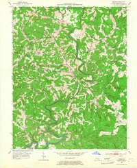
1952 Map of Dykes
USGS Topo · Published 1954About this map
Buck Creek carves a deep, winding path through the heart of this landscape, its tight meanders defining the agricultural and social centers of The Bent and Dykes. In the early 1950s, this portion of Pulaski County shows a pattern of ridge-top settlements and hollow-bottom homesteads, with the Cumberland National Forest reclaiming the southeastern terrain. Local life is anchored by small rural institutions like Randall Chapel, the Sears School, and the White Lily School, while the prominence of Mt Victory Lookout Tower suggests the area's wooded and elevated character. Genealogists will find many family-named cemeteries such as Woodall Cem and Merritt Cem, reflecting generations of residence along the Long Hollow and White Lily Ridge. The presence of a Strip Mine in the north hints at the extractive industry shaping the land alongside the traditional farming communities of Bent and Malvin Hill.
Find a feature on this map
74 named features on this map. Tap any name to fly to it.
Don’t see what you’re looking for? This feature index may not catch every label — zoom into the map to look around manually.
Map Details
Editions of this 1952 Dykes Map
2 editions found
Other maps of this area

1890 · Williamsburg
USGS Topo · 1:125,000

1893 · London
USGS Topo · 1:125,000

1894 · Williamsburg
USGS Topo · 1:125,000

1897 · London
USGS Topo · 1:125,000

1932 · Burnside
USGS Topo · 1:62,500

1935 · Somerset
USGS Topo · 1:62,500

1952 · Hail
USGS Topo · 1:24,000

1952 · Billows
USGS Topo · 1:24,000

1952 · Ano
USGS Topo · 1:24,000

1952 · Shopville
USGS Topo · 1:24,000