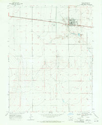
1968 Map of Eads
USGS Topo · Published 1971About this map
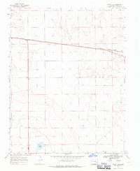
The high plains settlement of Eads serves as the focal point of this late-1960s survey, illustrating a community structured by its position along the Missouri Pacific railroad. The town's civic character is defined by the High Sch, a local Cem, and amenities such as the Country Club and the Fairground situated to the north. These features suggest a regional hub for the surrounding Kiowa County ranching and farming lands.
Find a feature on this map
16 named features on this map. Tap any name to fly to it.
Don’t see what you’re looking for? This feature index may not catch every label — zoom into the map to look around manually.
Map Details
Editions of this 1968 Eads Map
This is the sole edition of this map. No revisions or reprints were ever made.
Other maps of this area

1891 · Kit Carson
USGS Topo · 1:125,000

1892 · Lamar
USGS Topo · 1:125,000
1893 · Kit Carson
USGS Topo · 1:125,000

1954 · Lamar
USGS Topo · 1:250,000

1958 · Lamar
USGS Topo · 1:250,000
1967 · Neenoshe Reservoir
USGS Topo · 1:24,000
1968 · Rose Ranch
USGS Topo · 1:24,000
1968 · Alkali Lake
USGS Topo · 1:24,000
1968 · Swede Lake
USGS Topo · 1:24,000
1968 · Hawkins
USGS Topo · 1:24,000