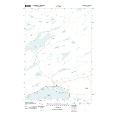
2010 Map of Eagle Bay
USGS Topo · Published 2010About this map
Eagle Bay and Inlet serve as the primary hubs for this region of the Adirondacks, situated along the northern reaches of the Fulton Chain Lakes. The landscape is defined by an intricate network of water bodies and high peaks, including Big Moose Lake in the northwest and the prominent Cascade Mountain and Black Bear Mountain to the southeast. Transport across this terrain relies on historic corridors like Uncas Rd and Big Moose RD, which connect scattered shoreline settlements with more isolated interior locations.
Find a feature on this map
65 named features on this map. Tap any name to fly to it.
Don’t see what you’re looking for? This feature index may not catch every label — zoom into the map to look around manually.
Map Details
Editions of this 2010 Eagle Bay Map
This is the sole edition of this map. No revisions or reprints were ever made.
Other maps of this area

1900 · Canada Lake
USGS Topo · 1:62,500

1901 · Old Forge
USGS Topo · 1:62,500

1903 · Big Moose
USGS Topo · 1:62,500

1903 · West Canada Lakes
USGS Topo · 1:62,500

1903 · Raquette Lake
USGS Topo · 1:62,500

1950 · Utica
USGS Topo · 1:250,000

1954 · Old Forge
USGS Topo · 1:62,500

1954 · West Canada Lakes
USGS Topo · 1:62,500
1954 · Raquette Lake
USGS Topo · 1:62,500

1954 · Big Moose
USGS Topo · 1:62,500