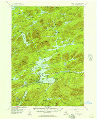
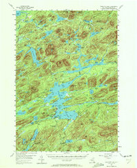
1954 Map of Raquette Lake
USGS Topo · Published 1957About this map
Deep in the Adirondack Park, the lake-studded landscape of Hamilton County is captured here during the mid-1950s. The region is defined by complex water systems, where the Salmon River and Shingle Shanty Brook wind between peaks like Salmon Lake Mtn and Estelle Mtn. A significant portion of the area reflects its transition from early industrial use to conservation and recreation, evidenced by the Railroad Grade running near Little Salmon Lake and the various named camps and points along the shorelines. On the shores of Raquette Lake, small social hubs like Deerland Camp and the St Williams Ch serve as local landmarks. The presence of the Raquette Lake Sch and a Lookout Tower on Salmon Lake Mtn indicates a permanent infrastructure supporting both the local community and wilderness management in this heavily forested interior.
Find a feature on this map
135 named features on this map. Tap any name to fly to it.
Don’t see what you’re looking for? This feature index may not catch every label — zoom into the map to look around manually.
Map Details
Editions of this 1954 Raquette Lake Map
5 editions found
Other maps of this area

1899 · Indian Lake
USGS Topo · 1:62,500

1900 · Canada Lake
USGS Topo · 1:62,500

1901 · Old Forge
USGS Topo · 1:62,500

1902 · Indian Lake
USGS Topo · 1:62,500

1903 · Big Moose
USGS Topo · 1:62,500

1903 · West Canada Lakes
USGS Topo · 1:62,500

1903 · Raquette Lake
USGS Topo · 1:62,500

1903 · Blue Mountain
USGS Topo · 1:62,500

1904 · Long Lake
USGS Topo · 1:62,500

1907 · Tupper Lake
USGS Topo · 1:62,500