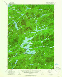
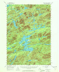
1954 Map of Raquette Lake
USGS Topo · Published 1962About this map
The Adirondack State Park shoreline is defined by the intricate finger-like bays of Raquette Lake, where mid-century wilderness recreation and historic estates converge. The settlement of Raquette Lake serves as a central hub, featuring the Raquette Lake Sch and nearby St Williams Ch on the water's edge. To the south, the storied Sagamore estate sits near the headwaters, while the northern reaches show a landscape transitioning from the era of heavy timber harvesting to one of preservation. Traces of industrial history are visible in the Railroad Grade winding through the woods, while the Canoe Carry labels between Utowana Lake and the Marion River highlight the persistent importance of traditional water travel routes. From Lake Lila in the northwest to the peaks of the Blue Ridge, this map documents a time when secluded camps like Deerland Camp and public Golden Beach Campsite were primary gateways to the interior.
Find a feature on this map
88 named features on this map. Tap any name to fly to it.
Don’t see what you’re looking for? This feature index may not catch every label — zoom into the map to look around manually.
Map Details
Editions of this 1954 Raquette Lake Map
5 editions found
Other maps of this area

1899 · Indian Lake
USGS Topo · 1:62,500

1900 · Canada Lake
USGS Topo · 1:62,500

1901 · Old Forge
USGS Topo · 1:62,500

1902 · Indian Lake
USGS Topo · 1:62,500

1903 · Big Moose
USGS Topo · 1:62,500

1903 · West Canada Lakes
USGS Topo · 1:62,500

1903 · Raquette Lake
USGS Topo · 1:62,500

1903 · Blue Mountain
USGS Topo · 1:62,500

1904 · Long Lake
USGS Topo · 1:62,500

1907 · Tupper Lake
USGS Topo · 1:62,500