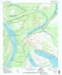
1994 Map of Eagle Bend
USGS Topo · Published 1995About this map
Mississippi River shifts and historical oxbow formations define this landscape along the border of Louisiana and Mississippi. The complex hydrology of the region is evident in the numerous water bodies like Chotard Lake, Eagle Lake, and Albemarle Lake, which represent former channels of the river. The small settlement of Brunswick serves as a focal point for local history, supported by the Brunswick Cem and Mt Olive Ch. Large landmasses such as Henderson Island and Australia Island are bound by the main river channel and the Willow Cutoff, illustrating the constant evolution of the riverbank. This map, updated with 1990s revisions, provides a clear view of the complex parish and county boundaries that often follow these shifting waters, including the intersections of Warren, Issaquena, Madison, and East Carroll jurisdictions.
Find a feature on this map
39 named features on this map. Tap any name to fly to it.
Don’t see what you’re looking for? This feature index may not catch every label — zoom into the map to look around manually.
Map Details
Editions of this 1994 Eagle Bend Map
This is the sole edition of this map. No revisions or reprints were ever made.
Other maps of this area

1909 · Millikens Bend
USGS Topo · 1:24,000

1909 · Tallulah
USGS Topo · 1:24,000

1918 · Vicksburg
USGS Topo · 1:62,500

1939 · Onward
USGS Topo · 1:62,500

1939 · Talla Bena
USGS Topo · 1:62,500

1939 · Alsatia
USGS Topo · 1:62,500

1941 · Vicksburg
USGS Topo · 1:62,500

1955 · Jackson
USGS Topo · 1:250,000

1961 · Jackson
USGS Topo · 1:250,000

1962 · Jackson
USGS Topo · 1:250,000