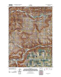
2011 Map of Eagle Butte
USGS Topo · Published 2011About this map
The Warm Springs River and Deschutes River converge in this high-desert landscape, creating a rugged geography defined by deep canyons and prominent volcanic rises. The local economy and cultural footprint are anchored by the Kah-Nee-Ta Resort in the north and the settlement of Mecca along the river banks. This survey captures the transition between recreational development and traditional land use, as seen in the presence of McKinley Corral and the Dry Creek Horse Camp.
Find a feature on this map
40 named features on this map. Tap any name to fly to it.
Don’t see what you’re looking for? This feature index may not catch every label — zoom into the map to look around manually.
Map Details
Editions of this 2011 Eagle Butte Map
This is the sole edition of this map. No revisions or reprints were ever made.
Other maps of this area

1928 · Madras
USGS Topo · 1:125,000

1931 · Madras
USGS Topo · 1:125,000

1955 · Bend
USGS Topo · 1:250,000

1957 · Bend
USGS Topo · 1:250,000

1958 · Bend
USGS Topo · 1:250,000
1962 · Simnasho
USGS Topo · 1:24,000
1962 · Kaskela
USGS Topo · 1:24,000

1962 · Eagle Butte
USGS Topo · 1:24,000
1962 · Seekseequa Junction
USGS Topo · 1:24,000

1962 · Gateway
USGS Topo · 1:24,000