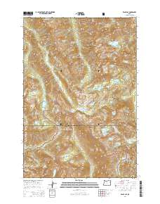
2014 Map of Eagle Cap
USGS Topo · Published 2014About this map
Eagle Cap stands as a central peak within the high-altitude landscape of the Wallowa Mountains, where the boundaries of the Wallowa National Forest and Whitman National Forest converge. This 2014 survey documents a glaciated wilderness defined by prominent summits such as Sacajawea Peak and the Matterhorn, alongside the persistent Benson Glacier. The terrain is characterized by a dense concentration of alpine water bodies, including the Lake Basin and Mirror Lake, which feed the headwaters of the Lostine River and the Minam River. Strategic mountain crossings like Horton Pass, Glacier Pass, and Frazier Pass connect these isolated basins across the Hurricane Divide. The map detail reveals the complex hydrology of the region, where the West Fork Wallowa River and East Fork Eagle Creek originate among the cirques and moraines of the high interior.
Find a feature on this map
59 named features on this map. Tap any name to fly to it.
Don’t see what you’re looking for? This feature index may not catch every label — zoom into the map to look around manually.
Map Details
Editions of this 2014 Eagle Cap Map
This is the sole edition of this map. No revisions or reprints were ever made.
Other maps of this area

1954 · Cornucopia
USGS Topo · 1:62,500

1954 · Eagle Cap
USGS Topo · 1:62,500

1955 · Grangeville
USGS Topo · 1:250,000

1957 · Enterprise
USGS Topo · 1:62,500

1957 · Joseph
USGS Topo · 1:62,500

1959 · Grangeville
USGS Topo · 1:250,000

1986 · Enterprise
USGS Topo · 1:100,000
1990 · Krag Peak
USGS Topo · 1:24,000

1990 · Chief Joseph Mtn
USGS Topo · 1:24,000
1990 · Eagle Cap
USGS Topo · 1:24,000