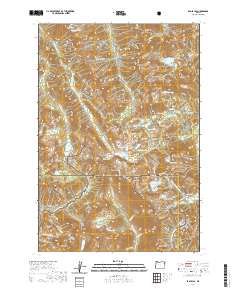
2020 Map of Eagle Cap
USGS Topo · Published 2020About this map
Eagle Cap Summit rises at the heart of this high-elevation wilderness within the Wallowa National Forest. The landscape is defined by its glacial hydrology, where subalpine water bodies like Mirror Lake and Minam Lake feed a network of protected waterways including the Lostine Wild and Scenic River and the Minam Wild and Scenic River. The terrain is characterized by sharp divides and peaks, notably Sacajawea Peak, the Matterhorn, and Needle Point. This 2020 survey documents the intricate trail systems that navigate these summits, such as the Ivan Carper trail, and the high passes like Horton Pass and Frazier Pass that connect the Minam River and E Eagle Creek drainages. The map provides a contemporary view of the boundary between Union and Wallowa counties, highlighting the convergence of the Whitman National Forest and several scenic river corridors.
Find a feature on this map
88 named features on this map. Tap any name to fly to it.
Don’t see what you’re looking for? This feature index may not catch every label — zoom into the map to look around manually.
Map Details
Editions of this 2020 Eagle Cap Map
This is the sole edition of this map. No revisions or reprints were ever made.
Other maps of this area

1954 · Cornucopia
USGS Topo · 1:62,500

1954 · Eagle Cap
USGS Topo · 1:62,500

1955 · Grangeville
USGS Topo · 1:250,000

1957 · Enterprise
USGS Topo · 1:62,500

1957 · Joseph
USGS Topo · 1:62,500

1959 · Grangeville
USGS Topo · 1:250,000

1986 · Enterprise
USGS Topo · 1:100,000
1990 · Krag Peak
USGS Topo · 1:24,000

1990 · Chief Joseph Mtn
USGS Topo · 1:24,000
1990 · Eagle Cap
USGS Topo · 1:24,000