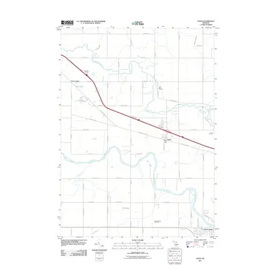
2011 Map of Eagle
USGS Topo · Published 2011About this map
The Grand River and Looking Glass River define the winding hydrology of this Michigan landscape, framing a transition from the developing northern edge of Grand Ledge to the rural crossroads of Eagle. The 2011 survey reveals a territory where modern infrastructure, like the Portland Rest Area along the interstate, intersects with long-standing community landmarks. Genealogists and local historians can find several established burial grounds, including North Eagle Cemetery, Niles Cemetery, and Union Cemetery, which anchor the local memory of the surrounding farmsteads. Settlement patterns are clustered around traditional hubs such as Frost Corners and the Eagle Post Office, while the southern reaches of the map show the recreational layout of the Ledge Meadows Golf Course near the riverbanks. The intricate network of local routes like Clintonia Rd and W Grand River Hwy connects these dispersed hamlets across a terrain carved by Frayer Creek and Sandstone Creek.
Find a feature on this map
57 named features on this map. Tap any name to fly to it.
Don’t see what you’re looking for? This feature index may not catch every label — zoom into the map to look around manually.
Map Details
Editions of this 2011 Eagle Map
This is the sole edition of this map. No revisions or reprints were ever made.
Other maps of this area

1910 · Lansing
USGS Topo · 1:62,500

1912 · Lansing
USGS Topo · 1:62,500

1927 · De Witt
USGS Topo · 1:62,500

1945 · Portland
USGS Topo · 1:62,500

1949 · Charlotte
USGS Topo · 1:62,500

1958 · Grand Rapids
USGS Topo · 1:250,000

1961 · Grand Rapids
USGS Topo · 1:250,000

1962 · Grand Rapids
USGS Topo · 1:250,000
1965 · Wacousta
USGS Topo · 1:24,000
1965 · Dimondale
USGS Topo · 1:24,000