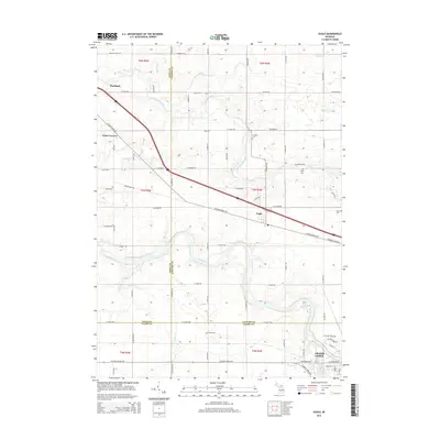
2014 Map of Eagle
USGS Topo · Published 2014About this map
Looking Glass River and the Grand River converge in this central Michigan landscape, defining the topography across the borders of Ionia, Clinton, and Eaton counties. The settlement of Eagle sits along the W Grand River Hwy, while the northwest corner includes a portion of Portland. This 2014 survey documents a predominantly agricultural region interspersed with small communities like Frost Corners and the northern edge of Grand Ledge. Genealogists will find significant value in the distribution of rural burial grounds, including N Eagle Cem, Eddy Cem, and Niles Cem. The map's detailed drainage network, featuring McCausey Br, Kramer Drain, and Sandstone Cr, illustrates the hydraulic complexity of the plains before they meet the more developed corridors near the E Grand Ledge Hwy.
Find a feature on this map
50 named features on this map. Tap any name to fly to it.
Don’t see what you’re looking for? This feature index may not catch every label — zoom into the map to look around manually.
Map Details
Editions of this 2014 Eagle Map
This is the sole edition of this map. No revisions or reprints were ever made.
Other maps of this area

1910 · Lansing
USGS Topo · 1:62,500

1912 · Lansing
USGS Topo · 1:62,500

1927 · De Witt
USGS Topo · 1:62,500

1945 · Portland
USGS Topo · 1:62,500

1949 · Charlotte
USGS Topo · 1:62,500

1958 · Grand Rapids
USGS Topo · 1:250,000

1961 · Grand Rapids
USGS Topo · 1:250,000

1962 · Grand Rapids
USGS Topo · 1:250,000
1965 · Wacousta
USGS Topo · 1:24,000
1965 · Dimondale
USGS Topo · 1:24,000