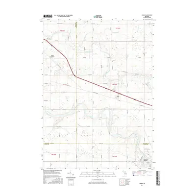
2017 Map of Eagle
USGS Topo · Published 2017About this map
The Looking Glass River and the Grand River converge toward the northwestern and southeastern reaches of this landscape, defining the rural character of Clinton and Eaton Counties. Centered on the village of Eagle, the area maintains a layout of agricultural plots and drainage systems like the Kramer Drain and McCausey Br. Transportation is dominated by the modern diagonal of the Grand River Hwy, which cuts across older road networks such as W Herbison Rd and Cutler Rd. For those tracing local families, the map includes several small burial sites, including North Eagle Cem, Eddy Cem, and Union Cem. The periphery of the sheet captures the edges of larger communities, with Portland appearing in the northwest corner and the outskirts of Grand Ledge visible in the southeast, providing a clear view of the transitions between small-town centers and the surrounding farm country.
Find a feature on this map
74 named features on this map. Tap any name to fly to it.
Don’t see what you’re looking for? This feature index may not catch every label — zoom into the map to look around manually.
Map Details
Editions of this 2017 Eagle Map
This is the sole edition of this map. No revisions or reprints were ever made.
Other maps of this area
1910 · Lansing
USGS Topo · 1:62,500
1912 · Lansing
USGS Topo · 1:62,500
1927 · De Witt
USGS Topo · 1:62,500
1945 · Portland
USGS Topo · 1:62,500
1949 · Charlotte
USGS Topo · 1:62,500
1958 · Grand Rapids
USGS Topo · 1:250,000
1961 · Grand Rapids
USGS Topo · 1:250,000
1962 · Grand Rapids
USGS Topo · 1:250,000
1965 · Wacousta
USGS Topo · 1:24,000
1965 · Dimondale
USGS Topo · 1:24,000