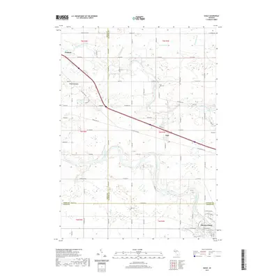
2019 Map of Eagle
USGS Topo · Published 2019About this map
The Grand River and the Looking Glass River define the winding hydrology of this Mid-Michigan landscape, converging toward the west. In the southeast corner, the growing outskirts of Grand Ledge show a transition from dense residential streets like Pleasant St and Jones St to the sprawling agricultural tracts that dominate the intersection of Eaton, Clinton, and Ionia Counties. The small community of Eagle sits centrally along the corridor of W Grand River Hwy, while Frost Corners and the edge of Portland appear in the northwest. Several rural burial grounds, including North Eagle Cem and Union Cem, are preserved among the farm fields. The map documents a complex drainage network where natural features like Sandstone Cr and Frazer Cr are supplemented by man-made conduits such as Kramer Drain.
Find a feature on this map
52 named features on this map. Tap any name to fly to it.
Don’t see what you’re looking for? This feature index may not catch every label — zoom into the map to look around manually.
Map Details
Editions of this 2019 Eagle Map
This is the sole edition of this map. No revisions or reprints were ever made.
Other maps of this area

1910 · Lansing
USGS Topo · 1:62,500

1912 · Lansing
USGS Topo · 1:62,500

1927 · De Witt
USGS Topo · 1:62,500

1945 · Portland
USGS Topo · 1:62,500

1949 · Charlotte
USGS Topo · 1:62,500

1958 · Grand Rapids
USGS Topo · 1:250,000

1961 · Grand Rapids
USGS Topo · 1:250,000

1962 · Grand Rapids
USGS Topo · 1:250,000
1965 · Wacousta
USGS Topo · 1:24,000
1965 · Dimondale
USGS Topo · 1:24,000