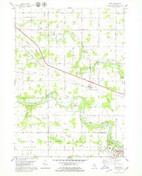
1978 Map of Eagle
USGS Topo · Published 1979About this map
The Grand River and Looking Glass River define the winding hydrology of this Clinton County landscape, where the Chesapeake and Ohio railroad corridor cuts a sharp diagonal through the agricultural terrain. The village of Eagle sits centrally, while the edge of Grand Ledge appears in the southeast corner near the sandstone formations of Fitzgerald Park. Extensive gravel extraction is evident along the river terraces, with numerous Gravel Pits concentrated near the water's edge.
Find a feature on this map
39 named features on this map. Tap any name to fly to it.
Don’t see what you’re looking for? This feature index may not catch every label — zoom into the map to look around manually.
Map Details
Editions of this 1978 Eagle Map
This is the sole edition of this map. No revisions or reprints were ever made.
Other maps of this area

1910 · Lansing
USGS Topo · 1:62,500

1912 · Lansing
USGS Topo · 1:62,500

1927 · De Witt
USGS Topo · 1:62,500

1945 · Portland
USGS Topo · 1:62,500

1949 · Charlotte
USGS Topo · 1:62,500

1958 · Grand Rapids
USGS Topo · 1:250,000

1961 · Grand Rapids
USGS Topo · 1:250,000

1962 · Grand Rapids
USGS Topo · 1:250,000
1965 · Wacousta
USGS Topo · 1:24,000
1965 · Dimondale
USGS Topo · 1:24,000