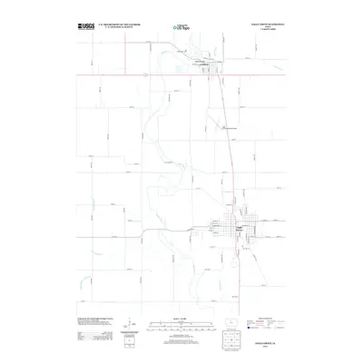
2013 Map of Eagle Grove
USGS Topo · Published 2013About this map
The Boone River snakes through this section of Wright County, creating a natural border between the settled streets of Goldfield and the larger hub of Eagle Grove. This landscape is defined by a sophisticated water management network, evidenced by the numerous engineered waterways like Ditch Number 9 and Ditch Number 4 that support the surrounding agricultural plains. The northern settlement of Goldfield is anchored by the Goldfield Bridge and the Oak Ridge Golf Course, while to the south, Eagle Grove shows a dense residential grid supported by the Eagle Grove Municipal Airport. Local landmarks such as Buttermilk Cr and the small locality of Bac Grove provide specific points of interest for those tracing family roots in this part of Iowa. The transition from river bottom to surveyed township lines reveals the enduring geometry of Midwestern development as it appeared in the early 21st century.
Find a feature on this map
77 named features on this map. Tap any name to fly to it.
Don’t see what you’re looking for? This feature index may not catch every label — zoom into the map to look around manually.
Map Details
Editions of this 2013 Eagle Grove Map
This is the sole edition of this map. No revisions or reprints were ever made.
Other maps of this area

1923 · Fort Dodge
USGS Topo · 1:62,500

1954 · Waterloo
USGS Topo · 1:250,000

1954 · Fort Dodge
USGS Topo · 1:250,000

1955 · Waterloo
USGS Topo · 1:250,000

1957 · Fort Dodge
USGS Topo · 1:250,000

1958 · Fort Dodge
USGS Topo · 1:250,000

1972 · Kanawha SE
USGS Topo · 1:24,000

1972 · Renwick
USGS Topo · 1:24,000
1972 · Hardy
USGS Topo · 1:24,000

1978 · Holmes
USGS Topo · 1:24,000