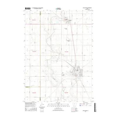
2015 Map of Eagle Grove
USGS Topo · Published 2015About this map
Eagle Grove and Goldfield serve as the primary population centers in this agricultural portion of Wright County, where the Boone River carves a winding path through the landscape. The river's natural meanders contrast with an extensive network of engineered waterways, including Ditch Number 4, Ditch Number 15, and Drainage Ditch Number 102, which reflect decades of landscape modification for regional farming. Genealogists will find several significant burial sites, such as the Wright County Burying Grounds and the Rose Hill Cem south of Goldfield. The layout of Eagle Grove is detailed down to its street grid, featuring E Broadway St and numerous numbered avenues, while the Eagle Grove Municipal Airport stands as a notable landmark to the north of the city proper. These features illustrate a rural Iowa community defined by its water management and established small-town infrastructure.
Find a feature on this map
95 named features on this map. Tap any name to fly to it.
Don’t see what you’re looking for? This feature index may not catch every label — zoom into the map to look around manually.
Map Details
Editions of this 2015 Eagle Grove Map
This is the sole edition of this map. No revisions or reprints were ever made.
Other maps of this area

1923 · Fort Dodge
USGS Topo · 1:62,500

1954 · Waterloo
USGS Topo · 1:250,000

1954 · Fort Dodge
USGS Topo · 1:250,000

1955 · Waterloo
USGS Topo · 1:250,000

1957 · Fort Dodge
USGS Topo · 1:250,000

1958 · Fort Dodge
USGS Topo · 1:250,000

1972 · Kanawha SE
USGS Topo · 1:24,000

1972 · Renwick
USGS Topo · 1:24,000
1972 · Hardy
USGS Topo · 1:24,000

1978 · Holmes
USGS Topo · 1:24,000