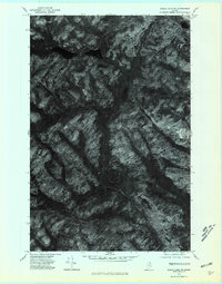
1975 Map of Eagle Lake SW
USGS Topo · Published 1981About this map
Wallagrass Stream and the surrounding timberlands of northern Maine are captured in this orthophoto quadrangle, based on aerial photography from the mid-1970s. The map reveals the intricate drainage patterns of the region, where the Birch River and Birch Branch cut through heavily forested terrain. This specific photographic record provides a clear look at the undeveloped character of the landscape before modern commercial forestry practices and road networks reached their current extent. The central portion of the sheet is dominated by the elongated Dickwood Lake, while the northern edge features the Wallagrass Lakes. Unlike traditional topographic maps, this orthophoto uses rectified imagery to show the actual forest cover and land use transitions in Aroostook County, offering a precise visual baseline for environmental and property historians.
Find a feature on this map
5 named features on this map. Tap any name to fly to it.
Don’t see what you’re looking for? This feature index may not catch every label — zoom into the map to look around manually.
Map Details
Editions of this 1975 Eagle Lake SW Map
This is the sole edition of this map. No revisions or reprints were ever made.
Other maps of this area

1928 · Eagle Lake
USGS Topo · 1:48,000

1928 · Winterville
USGS Topo · 1:48,000

1930 · St Francis
USGS Topo · 1:48,000

1931 · Fish River Lake
USGS Topo · 1:48,000

1931 · Eagle Lake
USGS Topo · 1:62,500

1931 · Winterville
USGS Topo · 1:62,500

1933 · St Francis
USGS Topo · 1:62,500

1935 · Fish River Lake
USGS Topo · 1:62,500

1954 · Presque Isle
USGS Topo · 1:250,000

1958 · Presque Isle
USGS Topo · 1:250,000