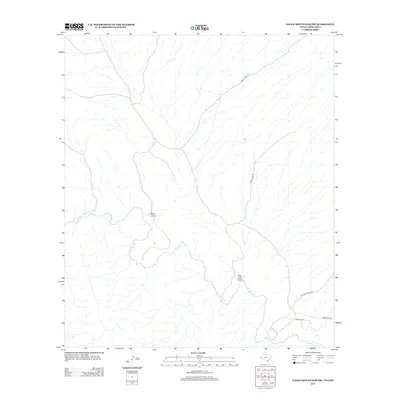
2012 Map of Eagle Mountains SW
USGS Topo · Published 2012About this map
The Rio Grande serves as the international boundary in this 2012 survey of the borderlands between Texas and Chihuahua. The landscape is defined by the drainage patterns of arid watercourses like Mule Canyon and Red Light Draw, which cut toward the river valley. Agricultural and ranching interests are localized near the river plain, represented by the Guerra Farm and Bramlett Ranch. Transportation in this sparsely populated region relies on unpaved routes such as August Well Rd and Pinkie Tank Rd, reflecting the remote nature of the terrain. The proximity of Oxford Canyon Rd and Bramlett Rd to the river highlights the importance of the alluvial corridor for navigation and access in an otherwise difficult environment.
Find a feature on this map
9 named features on this map. Tap any name to fly to it.
Don’t see what you’re looking for? This feature index may not catch every label — zoom into the map to look around manually.
Map Details
Editions of this 2012 Eagle Mountains SW Map
This is the sole edition of this map. No revisions or reprints were ever made.
Other maps of this area

1897 · Eagle Mountain
USGS Topo · 1:125,000

1916 · Eagle Mountain
USGS Topo · 1:125,000

1959 · Marfa
USGS Topo · 1:250,000

1965 · Marfa
USGS Topo · 1:250,000
1972 · Eagle Mountains NW
USGS Topo · 1:24,000
1972 · Bramlett Ranch
USGS Topo · 1:24,000
1972 · Eagle Mountains SE
USGS Topo · 1:24,000
1972 · Indian Hot Springs
USGS Topo · 1:24,000
1972 · Eagle Mountains SW
USGS Topo · 1:24,000
1972 · Eagle Mountains NE
USGS Topo · 1:24,000