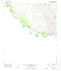
1972 Map of Bramlett Ranch
USGS Topo · Published 1975About this map
The Rio Grande carves a winding path along the international border in this early 1970s topographic study of Hudspeth County. This arid landscape is defined by the presence of isolated settlements and mineral exploration, notably the Bramlett Ranch and the settlement at Boykin. High in the eastern breaks, the Purple Sage Mine and several Drill Holes indicate a history of resource extraction near the rim of Eagle Canyon. The map reveals the sparse infrastructure of the Trans-Pecos region, where transit is often limited to a single Jeep Trail cutting across the desert floor toward the river. Seasonal drainage patterns like Squaw Creek are clearly delineated, illustrating the stark hydrology of the Chihuahuan Desert before the era of intensive modern development. This document captures a remote frontier corridor where topography dictated the limits of ranching and mining life.
Find a feature on this map
12 named features on this map. Tap any name to fly to it.
Don’t see what you’re looking for? This feature index may not catch every label — zoom into the map to look around manually.
Map Details
Editions of this 1972 Bramlett Ranch Map
This is the sole edition of this map. No revisions or reprints were ever made.
Other maps of this area

1892 · Chispa
USGS Topo · 1:125,000

1895 · Chispa
USGS Topo · 1:125,000

1897 · Eagle Mountain
USGS Topo · 1:125,000

1897 · Chispa
USGS Topo · 1:125,000

1916 · Eagle Mountain
USGS Topo · 1:125,000

1959 · Marfa
USGS Topo · 1:250,000

1965 · Marfa
USGS Topo · 1:250,000
1972 · Lobo SW
USGS Topo · 1:24,000
1972 · Mesquite Spring
USGS Topo · 1:24,000
1972 · Eagle Mountains SE
USGS Topo · 1:24,000