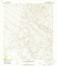
1972 Map of Eagle Mountains SE
USGS Topo · Published 1975About this map
Eagle Mountains dominate this high-desert landscape in Hudspeth County, where complex topography and deep canyons define the human footprint. The map documents a sparsely populated ranching and mining environment, centered around Indio Ranch and various water sources essential for survival in the Trans-Pecos. Resource extraction is evident at the Black Diamond Mine and several Prospect sites, while the network of Jeep Trails provides the primary means of navigating the intricate drainages of Oxford Canyon and Cottonwood Canyon. Water features like Oxford Spring and Squaw Spring serve as critical landmarks in an otherwise arid expanse. The elevation changes are most pronounced around Squaw Peak and Squaw Pass, illustrating the geographic barriers that directed historical travel through this part of West Texas.
Find a feature on this map
15 named features on this map. Tap any name to fly to it.
Don’t see what you’re looking for? This feature index may not catch every label — zoom into the map to look around manually.
Map Details
Editions of this 1972 Eagle Mountains SE Map
This is the sole edition of this map. No revisions or reprints were ever made.
Other maps of this area

1892 · Chispa
USGS Topo · 1:125,000

1895 · Chispa
USGS Topo · 1:125,000

1897 · Eagle Mountain
USGS Topo · 1:125,000

1897 · Chispa
USGS Topo · 1:125,000

1916 · Eagle Mountain
USGS Topo · 1:125,000

1959 · Marfa
USGS Topo · 1:250,000

1965 · Marfa
USGS Topo · 1:250,000
1972 · Lobo SW
USGS Topo · 1:24,000
1972 · Eagle Mountains NW
USGS Topo · 1:24,000
1972 · Bramlett Ranch
USGS Topo · 1:24,000