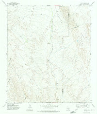
1972 Map of Lobo SW
USGS Topo · Published 1975About this map
Green River carves through this arid landscape in the early 1970s, marking a central drainage point between the high peaks of the Van Horn Mountains and the winding reaches of Eagle Canyon. This corner of Trans-Pecos Texas is defined by its mining history and remote ranching outposts, with visible landmarks like Taylor Ranch and the Mica Mine situated near the Hudspeth and Culberson county line. The presence of the Old Railroad Grade running parallel to the mountains hints at earlier industrial connectivity, while numerous prospects and mines like the Plata Verde Mine suggest a landscape long scrutinized for mineral wealth. Vital water sources for livestock and human habitation are recorded through scattered features such as Formwalt Windmill and various wells, illustrating the infrastructure required to sustain life in the high desert.
Find a feature on this map
21 named features on this map. Tap any name to fly to it.
Don’t see what you’re looking for? This feature index may not catch every label — zoom into the map to look around manually.
Map Details
Editions of this 1972 Lobo SW Map
This is the sole edition of this map. No revisions or reprints were ever made.
Other maps of this area

1892 · Chispa
USGS Topo · 1:125,000

1895 · Chispa
USGS Topo · 1:125,000

1897 · Eagle Mountain
USGS Topo · 1:125,000

1897 · Chispa
USGS Topo · 1:125,000

1916 · Eagle Mountain
USGS Topo · 1:125,000

1959 · Marfa
USGS Topo · 1:250,000

1965 · Marfa
USGS Topo · 1:250,000
1972 · Van Horn Wells
USGS Topo · 1:24,000
1972 · Lobo
USGS Topo · 1:24,000
1972 · Bramlett Ranch
USGS Topo · 1:24,000