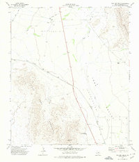
1972 Map of Van Horn Wells
USGS Topo · Published 1974About this map
Van Horn Wells marks a point of historical significance in this arid Trans-Pecos landscape, where the Southern Pacific railroad cuts through the high desert floor. The terrain is defined by the steep rises of the Van Horn Mountains and the Wylie Mountains, which frame a dramatic geological sink known as the Lobo Valley. This era of the early 1970s shows a landscape of specialized ranching and transportation, with the Farmer Ranch and Waddell Ranch maintaining a presence alongside a remote Landing Strip. Water remains the primary constraint for survival here, as evidenced by the intermittent course of Wild Horse Draw and the reliance on a scattered Water Tank. Local landmarks like Heliograph Hill suggest the area's strategic topography, while the isolated Grave near the historic wells offers a quiet detail for genealogists researching West Texas history.
Find a feature on this map
17 named features on this map. Tap any name to fly to it.
Don’t see what you’re looking for? This feature index may not catch every label — zoom into the map to look around manually.
Map Details
Editions of this 1972 Van Horn Wells Map
This is the sole edition of this map. No revisions or reprints were ever made.
Other maps of this area

1892 · Chispa
USGS Topo · 1:125,000

1895 · Chispa
USGS Topo · 1:125,000

1897 · Chispa
USGS Topo · 1:125,000

1906 · Van Horn
USGS Topo · 1:125,000

1954 · Van Horn
USGS Topo · 1:250,000

1958 · Van Horn
USGS Topo · 1:250,000

1959 · Marfa
USGS Topo · 1:250,000

1964 · Wild Horse
USGS Topo · 1:24,000
1964 · Hackett Peak
USGS Topo · 1:24,000

1964 · Van Horn
USGS Topo · 1:24,000