
1964 Map of Wild Horse
USGS Topo · Published 1967About this map
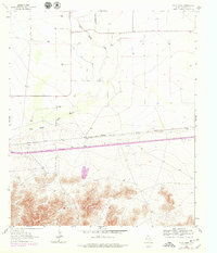
Wild Horse Creek defines the low-lying drainage of this West Texas landscape, winding northward through a corridor of rangeland and scrub. The southern portion of the map is dominated by the steep rising slopes of the Delaware Mountains, where Harper Ranch is situated at the foot of the high ground. The mid-century transportation network is clearly marked by the straight line of the Texas and Pacific railroad, which parallels a primary road corridor across the basin. Small pockets of activity are scattered across the valley, including Durrill Camp and the small settlement at Wild Horse. Evidence of local infrastructure and resource extraction is visible through several labeled Gravel Pit and Borrow Pit sites, alongside a dedicated Landing Strip serving this isolated stretch of Culberson County.
Find a feature on this map
9 named features on this map. Tap any name to fly to it.
Don’t see what you’re looking for? This feature index may not catch every label — zoom into the map to look around manually.
Map Details
Editions of this 1964 Wild Horse Map
2 editions found
Other maps of this area

1892 · Chispa
USGS Topo · 1:125,000

1895 · Chispa
USGS Topo · 1:125,000

1897 · Chispa
USGS Topo · 1:125,000

1906 · Van Horn
USGS Topo · 1:125,000

1954 · Van Horn
USGS Topo · 1:250,000

1958 · Van Horn
USGS Topo · 1:250,000

1959 · Marfa
USGS Topo · 1:250,000
1964 · Goat Canyon
USGS Topo · 1:24,000

1964 · Watson Ranch
USGS Topo · 1:24,000

1964 · Van Horn
USGS Topo · 1:24,000