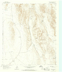
1964 Map of Goat Canyon
USGS Topo · Published 1967About this map
The Apache Mountains dominate the eastern half of this Trans-Pecos landscape, rising to peaks like Old Baldy and hiding deep cuts like Goat Canyon and Hackberry Canyon. This high-desert environment in the mid-1960s is defined by its water management and large-scale ranching operations. The presence of numerous earthen tanks, including Threemile Tank, Onemile Tank, and Five Point Tank, reveals the infrastructure required to sustain livestock in this arid terrain.
Find a feature on this map
20 named features on this map. Tap any name to fly to it.
Don’t see what you’re looking for? This feature index may not catch every label — zoom into the map to look around manually.
Map Details
Editions of this 1964 Goat Canyon Map
This is the sole edition of this map. No revisions or reprints were ever made.
Other maps of this area

1906 · Van Horn
USGS Topo · 1:125,000

1928 · Kent
USGS Topo · 1:125,000

1954 · Van Horn
USGS Topo · 1:250,000

1958 · Van Horn
USGS Topo · 1:250,000

1964 · Wild Horse
USGS Topo · 1:24,000

1964 · Watson Ranch
USGS Topo · 1:24,000
1964 · Plateau
USGS Topo · 1:24,000
1970 · Boracho
USGS Topo · 1:24,000
1970 · East Hunter Canyon
USGS Topo · 1:24,000

1972 · Seven Heart Gap
USGS Topo · 1:24,000