
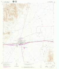
1964 Map of Van Horn
USGS Topo · Published 1967About this map
The high-desert crossroads of Van Horn serves as the focal point of this mid-1960s survey, situated between the Beach Mountains and the Wylie Mountains. The town's layout reflects a classic Texas railroad and highway corridor, anchored by the Texas and Pacific line. Community infrastructure is well-defined, ranging from the Eagle Sch and local Cem to recreation-focused sites like the Golf Course, Rodeo Ground, and an early Drive-in Theater. Beyond the town limits, the landscape transitions into ranching territory, with the Neal Ranch and Lipsey Ranch established near drainage systems like Hackberry Creek and Wild Horse Creek. The presence of the County Airfield and numerous borrow pits and quarries suggests the area's role as a transportation and materials hub for Far West Texas.
Find a feature on this map
24 named features on this map. Tap any name to fly to it.
Don’t see what you’re looking for? This feature index may not catch every label — zoom into the map to look around manually.
Map Details
Editions of this 1964 Van Horn Map
2 editions found
Other maps of this area

1892 · Chispa
USGS Topo · 1:125,000

1895 · Chispa
USGS Topo · 1:125,000

1897 · Chispa
USGS Topo · 1:125,000

1906 · Van Horn
USGS Topo · 1:125,000

1954 · Van Horn
USGS Topo · 1:250,000

1958 · Van Horn
USGS Topo · 1:250,000

1959 · Marfa
USGS Topo · 1:250,000

1964 · Wild Horse
USGS Topo · 1:24,000
1964 · Hackett Peak
USGS Topo · 1:24,000

1964 · Watson Ranch
USGS Topo · 1:24,000