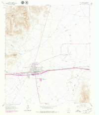
1964 Map of Van Horn
USGS Topo · Published 1979About this map
Van Horn serves as a critical West Texas crossroads on this survey, situated at the junction where the Missouri Pacific railroad cuts through a high-desert basin. The town's local infrastructure is well-defined, showing the Eagle Sch, a Cem, and a Rodeo Ground. To the east, the County Airfield and a Landing Strip indicate the area's importance for aviation, while leisure features like the Drive-in Theater and Golf Course reflect mid-century community life.
Find a feature on this map
24 named features on this map. Tap any name to fly to it.
Don’t see what you’re looking for? This feature index may not catch every label — zoom into the map to look around manually.
Map Details
Editions of this 1964 Van Horn Map
2 editions found

Other maps of this area

1892 · Chispa
USGS Topo · 1:125,000

1895 · Chispa
USGS Topo · 1:125,000

1897 · Chispa
USGS Topo · 1:125,000

1906 · Van Horn
USGS Topo · 1:125,000

1954 · Van Horn
USGS Topo · 1:250,000

1958 · Van Horn
USGS Topo · 1:250,000

1959 · Marfa
USGS Topo · 1:250,000

1964 · Wild Horse
USGS Topo · 1:24,000
1964 · Hackett Peak
USGS Topo · 1:24,000

1964 · Watson Ranch
USGS Topo · 1:24,000