
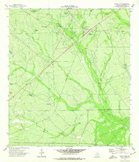
1940 Map of Eagle Pass
USGS Topo · Published 1959About this map
The Rio Grande defines the western edge of this 1940s landscape, serving as the international boundary between the United States and Mexico. This survey, compiled from 1939 aerial photography, reveals a borderland dominated by large ranching and farming operations. The settlement of Eagle Pass serves as the primary hub in the north, while the southern reaches feature the community of El Indio and extensive agricultural infrastructure, including the Milton Frank Farms and their nearby silos.
Find a feature on this map
29 named features on this map. Tap any name to fly to it.
Don’t see what you’re looking for? This feature index may not catch every label — zoom into the map to look around manually.
Map Details
Editions of this 1940 Eagle Pass Map
This is the sole edition of this map. No revisions or reprints were ever made.
Other maps of this area

1940 · Cometa
USGS Topo · 1:62,500

1940 · Paloma
USGS Topo · 1:62,500

1940 · Quemado
USGS Topo · 1:62,500

1940 · Chacon Creek
USGS Topo · 1:62,500

1941 · Botella Creek
USGS Topo · 1:62,500

1957 · Indio Creek
USGS Topo · 1:62,500

1957 · Botella Creek
USGS Topo · 1:62,500

1958 · Eagle Pass
USGS Topo · 1:250,000

1965 · Eagle Pass
USGS Topo · 1:250,000
1974 · Indian Tank
USGS Topo · 1:24,000