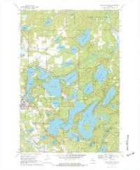
1970 Map of Eagle River East
USGS Topo · Published 1984About this map
Eagle River serves as the gateway to a sprawling network of interconnected glacial waterways in this 1970 survey of Vilas and Oneida counties. The landscape is defined by the massive reach of Eagle Lake, Catfish Lake, and Cranberry Lake, where the shoreline is dotted with summer destinations like Camp Hidden Hollow and Camp Marimeta. The Burnt Rollways Dam regulates the water levels for the region's prominent timber and recreational economy, while the Chicago and North Western railroad provides a critical land link through the lakeside settlements. Within the Nicolet National Forest, many smaller bodies of water such as Caspian Lake and Deerskin Lake remain largely undeveloped, punctuated only by gravel pits and isolated boat ramps. This era captures the transition of northern Wisconsin from a rugged timber frontier into a premier midwestern resort destination, evidenced by the proliferation of private camps and parks like Eagle Pines Park.
Find a feature on this map
64 named features on this map. Tap any name to fly to it.
Don’t see what you’re looking for? This feature index may not catch every label — zoom into the map to look around manually.
Map Details
Editions of this 1970 Eagle River East Map
3 editions found
Other maps of this area

1928 · Three Lakes
USGS Topo · 1:48,000

1930 · Robbins
USGS Topo · 1:48,000

1938 · Phelps
USGS Topo · 1:48,000

1938 · Three Lakes
USGS Topo · 1:48,000

1938 · Robbins
USGS Topo · 1:48,000

1945 · Three Lakes
USGS Topo · 1:48,000

1945 · Robbins
USGS Topo · 1:48,000

1946 · Star Lake
USGS Topo · 1:48,000

1950 · Phelps
USGS Topo · 1:48,000

1950 · Star Lake
USGS Topo · 1:48,000