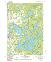
1970 Map of Eagle River East
USGS Topo · Published 1984About this map
The Chicago and North Western corridor defines the western edge of this 1970 snapshot, where the city of Eagle River sits at the gateway to a massive chain of glacial water bodies. The intricate hydrology of the region is evident in the sprawling interconnected basins of Eagle Lake, Catfish Lake, and Cranberry Lake, reaching south toward the Vilas and Oneida county line. Local land use is a mix of conservation and recreation, with large tracts of the Nicolet National Forest bordering private developments like Camp Marimeta and Honey Rock Camp.
Find a feature on this map
73 named features on this map. Tap any name to fly to it.
Don’t see what you’re looking for? This feature index may not catch every label — zoom into the map to look around manually.
Map Details
Editions of this 1970 Eagle River East Map
3 editions found
Other maps of this area

1928 · Three Lakes
USGS Topo · 1:48,000

1930 · Robbins
USGS Topo · 1:48,000

1938 · Phelps
USGS Topo · 1:48,000

1938 · Three Lakes
USGS Topo · 1:48,000

1938 · Robbins
USGS Topo · 1:48,000

1945 · Three Lakes
USGS Topo · 1:48,000

1945 · Robbins
USGS Topo · 1:48,000

1946 · Star Lake
USGS Topo · 1:48,000

1950 · Phelps
USGS Topo · 1:48,000

1950 · Star Lake
USGS Topo · 1:48,000