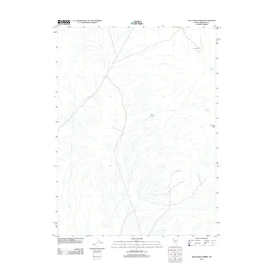
2011 Map of Eagle Rock Spring
USGS Topo · Published 2011About this map
The Lava Beds dominate the eastern reaches of this Pershing County landscape, where volcanic geology dictates the drainage and settlement patterns of the high desert. In the northern section, Lava Beds Camp sits near the headwaters of Lava Beds Creek, providing a rare point of human activity in an area defined by its reliance on isolated water sources. These vital springs, including Eagle Rock Spring, Mustang Spring, and Trail Springs, are scattered along the margins of the volcanic field and through the corridors of Trail Canyon. The map reveals a network of primitive roads and trails that navigate the complex terrain, tracing the paths between these watering holes and through the canyons. This 2011 survey documents a remote corner of the Great Basin where the presence of water at named springs continues to determine the accessibility of the volcanic highlands.
Find a feature on this map
7 named features on this map. Tap any name to fly to it.
Don’t see what you’re looking for? This feature index may not catch every label — zoom into the map to look around manually.
Map Details
Editions of this 2011 Eagle Rock Spring Map
This is the sole edition of this map. No revisions or reprints were ever made.
Other maps of this area

1886 · Granite Range
USGS Topo · 1:250,000

1894 · Granite Range
USGS Topo · 1:250,000

1931 · Lovelock
USGS Topo · 1:250,000

1935 · Lovelock
USGS Topo · 1:250,000

1955 · Lovelock
USGS Topo · 1:250,000

1959 · Lovelock
USGS Topo · 1:250,000

1980 · Dry Mountain NW
USGS Topo · 1:24,000

1980 · Eagle Rock Spring
USGS Topo · 1:24,000

1980 · Dry Mountain
USGS Topo · 1:24,000

1980 · Tenmile
USGS Topo · 1:24,000