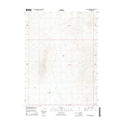
2014 Map of Eagle Rock Spring
USGS Topo · Published 2014About this map
Kumiva Valley dominates the western portion of this 2014 survey, illustrating the characteristic basin-and-range topography found in northern Pershing County. This landscape is defined by its vital water sources, including the eponymous Eagle Rock Spring, Mustang Spring, and Trail Spring, which serve as critical landmarks in an otherwise arid environment. The eastern terrain is marked by distinctive geological formations like The Lava Beds and the drainage of Lava Beds Cr, indicating the volcanic history of the region. A network of unimproved roads and trails, such as those through Trail Canyon, reflects the area's continued use for land management and recreation. The lack of permanent structures emphasizes the preserved, open character of this high-desert territory in the early 21st century.
Find a feature on this map
14 named features on this map. Tap any name to fly to it.
Don’t see what you’re looking for? This feature index may not catch every label — zoom into the map to look around manually.
Map Details
Editions of this 2014 Eagle Rock Spring Map
This is the sole edition of this map. No revisions or reprints were ever made.
Other maps of this area

1886 · Granite Range
USGS Topo · 1:250,000

1894 · Granite Range
USGS Topo · 1:250,000

1931 · Lovelock
USGS Topo · 1:250,000

1935 · Lovelock
USGS Topo · 1:250,000

1955 · Lovelock
USGS Topo · 1:250,000

1959 · Lovelock
USGS Topo · 1:250,000

1980 · Dry Mountain NW
USGS Topo · 1:24,000

1980 · Eagle Rock Spring
USGS Topo · 1:24,000

1980 · Dry Mountain
USGS Topo · 1:24,000

1980 · Tenmile
USGS Topo · 1:24,000