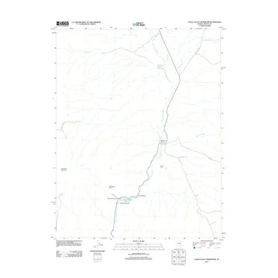
2012 Map of Eagle Valley Reservoir
USGS Topo · Published 2012About this map
Eagle Valley Reservoir and the surrounding high-desert terrain of Lincoln County define this landscape, where water management is central to the local geography. The reservoir is anchored by the Eagle Valley Reservoir Dam at the base of Horsethief Gulch, part of the larger Spring Valley State Park system. The map reveals a complex network of seasonal drainages, including the prominent Meadow Valley Wash, White Rock Wash, and Cottonwood Wash, which carve through the arid valley. Human presence is concentrated around the Seven L Ranch and the small community at Spring Valley. Notable geological and recreational landmarks such as Horsethief Mountain, State Line Canyon, and the distinctively named Window in Rock provide key navigational points for those exploring this part of eastern Nevada.
Find a feature on this map
19 named features on this map. Tap any name to fly to it.
Don’t see what you’re looking for? This feature index may not catch every label — zoom into the map to look around manually.
Map Details
Editions of this 2012 Eagle Valley Reservoir Map
This is the sole edition of this map. No revisions or reprints were ever made.
Other maps of this area

1885 · Pioche
USGS Topo · 1:250,000

1886 · Pioche
USGS Topo · 1:250,000

1921 · NW 1/4 Panaca
USGS Topo · 1:48,000

1954 · Caliente
USGS Topo · 1:250,000

1956 · Lund
USGS Topo · 1:250,000

1959 · Caliente
USGS Topo · 1:250,000

1960 · Lund
USGS Topo · 1:250,000

1970 · Pierson Summit
USGS Topo · 1:24,000

1970 · Parsnip Peak
USGS Topo · 1:24,000
1970 · Rose Valley
USGS Topo · 1:24,000