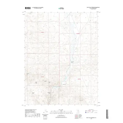
2018 Map of Eagle Valley Reservoir
USGS Topo · Published 2018About this map
Meadow Valley Wash flows southward through this high-altitude landscape in Lincoln County, feeding into the Eagle Valley Reservoir. The settlements of Spring Valley and Ursine sit along the valley floor, surrounded by the dramatic topography of the Wilson Creek Range. To the west, the terrain rises toward Horsethief Mtn, where a network of drainages including Horsethief Gulch, Horsethief Canyon, and Horsethief Spring suggest a history of local geographic naming. The area is characterized by these intermittent washes and canyons, such as State Line Canyon and Fulman Canyon, which define the drainage patterns of the eastern Nevada desert. Natural landmarks like Window in Rock and water sources such as Willow Spring provide specific points of interest within the vast public land survey sections of the region.
Find a feature on this map
21 named features on this map. Tap any name to fly to it.
Don’t see what you’re looking for? This feature index may not catch every label — zoom into the map to look around manually.
Map Details
Editions of this 2018 Eagle Valley Reservoir Map
This is the sole edition of this map. No revisions or reprints were ever made.
Other maps of this area

1885 · Pioche
USGS Topo · 1:250,000

1886 · Pioche
USGS Topo · 1:250,000

1921 · NW 1/4 Panaca
USGS Topo · 1:48,000

1954 · Caliente
USGS Topo · 1:250,000

1956 · Lund
USGS Topo · 1:250,000

1959 · Caliente
USGS Topo · 1:250,000

1960 · Lund
USGS Topo · 1:250,000

1970 · Pierson Summit
USGS Topo · 1:24,000

1970 · Parsnip Peak
USGS Topo · 1:24,000
1970 · Rose Valley
USGS Topo · 1:24,000