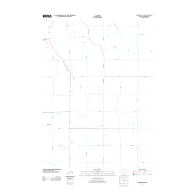
2013 Map of Earling NE
USGS Topo · Published 2013About this map
The Denison Municipal Airport sits in the northwest corner of this rural Crawford County landscape, where the agricultural grid is defined by a dense network of secondary roads and local connectors. This 2013 survey illustrates a classic Iowa section-line development pattern, with arterial routes like Donna Reed Rd and S Main Loop providing access to the expansive farmlands between the county's major waterways. The terrain is deeply etched by a system of winding creeks, most notably Coon Cr, which meanders through the central portion of the quadrangle. Other drainage patterns including Buck Cr and Willow Cr show how the local topography has influenced the placement of rural residences and the winding paths of roads like Coon Grove Ln. The map serves as a precise record of the early 21st-century infrastructure in this region south of Denison, preserving the names of the small farm roads and creek crossings that define the local geography.
Find a feature on this map
31 named features on this map. Tap any name to fly to it.
Don’t see what you’re looking for? This feature index may not catch every label — zoom into the map to look around manually.
Map Details
Editions of this 2013 Earling NE Map
This is the sole edition of this map. No revisions or reprints were ever made.
Other maps of this area

1954 · Omaha
USGS Topo · 1:250,000

1954 · Fort Dodge
USGS Topo · 1:250,000

1957 · Omaha
USGS Topo · 1:250,000

1957 · Fort Dodge
USGS Topo · 1:250,000

1958 · Omaha
USGS Topo · 1:250,000

1958 · Fort Dodge
USGS Topo · 1:250,000

1971 · Earling
USGS Topo · 1:24,000

1971 · Earling NE
USGS Topo · 1:24,000

1971 · Denison
USGS Topo · 1:24,000
1971 · Dow City
USGS Topo · 1:24,000