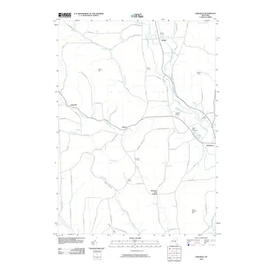
2010 Map of Earlville
USGS Topo · Published 2010About this map
The Chenango River valley serves as the primary corridor through this central New York landscape, connecting the villages of Earlville and Sherburne. In the early 21st century, the area remains defined by its rural heritage and network of small settlements like Smyrna, Upperville, and Sherburne Four Corners. The topography is marked by significant elevations such as Negro Hill and Steam Sawmill Hill, while the drainage patterns of Pleasant Brook and Fly Creek dictate the placement of historic farm-to-market roads. Genealogists will find a wealth of local data here, with several smaller burial grounds including Wilcox Cemetery, Stover Cemetery, and Reynolds Cemetery preserved across the hillsides. The northeastern corner is notable for the Earlville Reservoir and the Rogers State Game Farm, indicating the region's continued emphasis on conservation and water management alongside its agricultural roots.
Find a feature on this map
70 named features on this map. Tap any name to fly to it.
Don’t see what you’re looking for? This feature index may not catch every label — zoom into the map to look around manually.
Map Details
Editions of this 2010 Earlville Map
This is the sole edition of this map. No revisions or reprints were ever made.
Other maps of this area

1902 · Morrisville
USGS Topo · 1:62,500

1903 · Norwich
USGS Topo · 1:62,500

1907 · Sangerfield
USGS Topo · 1:62,500

1910 · New Berlin
USGS Topo · 1:62,500

1912 · New Berlin
USGS Topo · 1:62,500

1943 · Otselic
USGS Topo · 1:24,000

1943 · West Eaton
USGS Topo · 1:24,000

1943 · Hubbardsville
USGS Topo · 1:24,000

1943 · Sangerfield
USGS Topo · 1:62,500

1943 · Holmesville
USGS Topo · 1:24,000