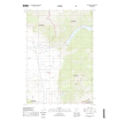
2020 Map of Earthquake Lake
USGS Topo · Published 2020About this map
Earthquake Lake and the Madison Slide dominate this topography, marking the dramatic geomorphic changes in the Madison River Canyon. The landscape transitions from the high peaks of the Henrys Lake Mountains and Sheep Mountain down to the Missouri Flats, where the Madison River flows westward. Human presence is etched into the terrain via roads like Greased Line Way and the Continental Divide Ranch. The map captures the complex boundary where the Gallatin National Forest, Beaverhead National Forest, and Targhee National Forest converge at the Continental Divide. This intersection of three national forests and the Montana-Idaho state line highlights a region managed for wilderness and grazing, evidenced by cattle-related labels like Sheep Creek Rd and the small settlement at Jensen.
Find a feature on this map
86 named features on this map. Tap any name to fly to it.
Don’t see what you’re looking for? This feature index may not catch every label — zoom into the map to look around manually.
Map Details
Editions of this 2020 Earthquake Lake Map
This is the sole edition of this map. No revisions or reprints were ever made.
Other maps of this area

1950 · Cliff Lake
USGS Topo · 1:62,500

1950 · Hebgen Dam
USGS Topo · 1:62,500

1950 · Upper Red Rock Lake
USGS Topo · 1:62,500

1955 · Ashton
USGS Topo · 1:250,000

1958 · Ashton
USGS Topo · 1:250,000

1960 · Ashton
USGS Topo · 1:250,000

1964 · Targhee Pass
USGS Topo · 1:24,000

1964 · Targhee Peak
USGS Topo · 1:24,000

1964 · Henrys Lake
USGS Topo · 1:62,500
1988 · Hidden Lake Bench
USGS Topo · 1:24,000