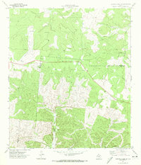
1971 Map of Earwood Creek SW
USGS Topo · Published 1974About this map
The East Prong Nueces River carves through this Edwards Plateau landscape, defining the rugged geography of the Edwards Co Real Co border during the early 1970s. The map illustrates a working ranching and resource extraction environment where water management is central to survival. Scattered across the drainage basins of Contrary Creek and Hunger Creek are functional landmarks like Blair Windmill and Water Tank Well, alongside numerous drill holes and gravel pits that suggest an active industrial presence. A network of unimproved roads and a Jeep Trail navigate the steep topography near Ranger Hollow, while a significant Pipeline cuts across the northern terrain. This survey provides an exact record of the physical infrastructure required to inhabit and work this remote section of the Texas Hill Country, from the isolated ranch wells to the boundary lines established between neighboring counties.
Find a feature on this map
13 named features on this map. Tap any name to fly to it.
Don’t see what you’re looking for? This feature index may not catch every label — zoom into the map to look around manually.
Map Details
Editions of this 1971 Earwood Creek SW Map
2 editions found
Other maps of this area

1893 · Rock Springs
USGS Topo · 1:125,000

1893 · Nueces
USGS Topo · 1:125,000

1896 · Nueces
USGS Topo · 1:125,000

1947 · Hackberry
USGS Topo · 1:62,500

1954 · Llano
USGS Topo · 1:250,000

1954 · San Antonio
USGS Topo · 1:250,000

1954 · Sonora
USGS Topo · 1:250,000

1955 · Llano
USGS Topo · 1:250,000

1956 · Llano
USGS Topo · 1:250,000

1957 · San Antonio
USGS Topo · 1:250,000