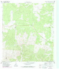
1971 Map of Earwood Creek SW
USGS Topo · Published 1987About this map
East Prong Nueces River carves through the landscape along the county boundary of Edwards Co and Real Co in this 1970s topographic record. The map documents a sparsely settled ranching and resource territory, characterized by isolated infrastructure like the Blair Windmill and several scattered Drill Holes. The drainage network is clearly defined by seasonal watercourses, including the aptly named Contrary Creek in the northwest and Hunger Creek to the northeast. Industrial activity is indicated by several small Gravel Pit operations and a significant Pipeline corridor that cuts across the central terrain. Local geography is further marked by named landforms such as Ranger Hollow, providing a clear look at the area's development before modern suburban expansion or changes in rural land use.
Find a feature on this map
13 named features on this map. Tap any name to fly to it.
Don’t see what you’re looking for? This feature index may not catch every label — zoom into the map to look around manually.
Map Details
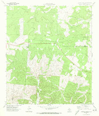
Editions of this 1971 Earwood Creek SW Map
2 editions found
Other maps of this area

1893 · Rock Springs
USGS Topo · 1:125,000

1893 · Nueces
USGS Topo · 1:125,000

1896 · Nueces
USGS Topo · 1:125,000

1947 · Hackberry
USGS Topo · 1:62,500

1954 · Llano
USGS Topo · 1:250,000

1954 · San Antonio
USGS Topo · 1:250,000

1954 · Sonora
USGS Topo · 1:250,000

1955 · Llano
USGS Topo · 1:250,000

1956 · Llano
USGS Topo · 1:250,000

1957 · San Antonio
USGS Topo · 1:250,000