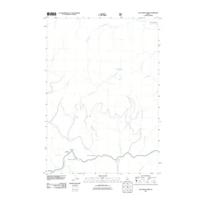
2011 Map of East Basin Creek
USGS Topo · Published 2011About this map
The Salmon River flows along the southern edge of this Custer County landscape, winding past the small settlement at Mormon Bend. This area of central Idaho is defined by its extensive drainage network, where the East Basin Creek and its many tributaries, such as Hay Creek and Short Creek, carve through the high terrain. The geography here is marked by an established culture of outdoor recreation, evidenced by a series of developed sites along the river corridor, including the Mormon Bend Campground, Riverside Campground, and Basin Creek Campground.
Find a feature on this map
26 named features on this map. Tap any name to fly to it.
Don’t see what you’re looking for? This feature index may not catch every label — zoom into the map to look around manually.
Map Details
Editions of this 2011 East Basin Creek Map
This is the sole edition of this map. No revisions or reprints were ever made.
Other maps of this area

1919 · Custer
USGS Topo · 1:125,000

1922 · Custer
USGS Topo · 1:125,000

1957 · Challis
USGS Topo · 1:250,000

1960 · Challis
USGS Topo · 1:250,000

1963 · Challis
USGS Topo · 1:250,000

1963 · Custer
USGS Topo · 1:24,000

1963 · Stanley
USGS Topo · 1:24,000

1963 · Basin Butte
USGS Topo · 1:24,000

1963 · Casino Lakes
USGS Topo · 1:24,000
1964 · Knapp Lakes
USGS Topo · 1:24,000