1982 Map of East Dixmont
USGS Topo · Published 1983About this map
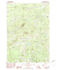
Peaked Mtn rises as a central landmark in this 1982 provisional survey of the Maine interior, where the borders of Penobscot and Waldo counties meet. The landscape is defined by a dense network of family-named cemeteries and small rural settlements like Dixmont Center, Newburgh Center, and Simpson Corners. These clusters of development are connected by historic thoroughfares including Garland Road and Kennebec Road.
Find a feature on this map
64 named features on this map. Tap any name to fly to it.
Don’t see what you’re looking for? This feature index may not catch every label — zoom into the map to look around manually.
Map Details
Editions of this 1982 East Dixmont Map
2 editions found

Other maps of this area

1900 · Bucksport
USGS Topo · 1:62,500

1902 · Bucksport
USGS Topo · 1:62,500

1902 · Bangor
USGS Topo · 1:62,500

1931 · Stetson
USGS Topo · 1:48,000

1932 · Brooks
USGS Topo · 1:62,500

1935 · Stetson
USGS Topo · 1:62,500

1942 · Bangor
USGS Topo · 1:62,500

1942 · Bucksport
USGS Topo · 1:62,500

1946 · Bangor
USGS Topo · 1:62,500

1948 · Bangor
USGS Topo · 1:250,000