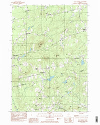
1982 Map of East Dixmont
USGS Topo · Published 1983About this map
The Penobscot and Waldo county line bisects this 1982 survey of south-central Maine, a region defined by its numerous small burial grounds and rural crossroads. Local history and genealogy interests are well-represented by a high density of family and community cemeteries, including the Graveyard Cem, Porter Cem, and the Pilgrims Home Cem near the southern border. Small village centers such as Simpson Corners, Dixmont Center, and East Dixmont anchor the township, connected by a network of unimproved roads that navigate the area's many peaks, including Peaked Mtn and Piper Mtn.
Find a feature on this map
57 named features on this map. Tap any name to fly to it.
Don’t see what you’re looking for? This feature index may not catch every label — zoom into the map to look around manually.
Map Details
Editions of this 1982 East Dixmont Map
2 editions found
Other maps of this area

1900 · Bucksport
USGS Topo · 1:62,500

1902 · Bucksport
USGS Topo · 1:62,500

1902 · Bangor
USGS Topo · 1:62,500

1931 · Stetson
USGS Topo · 1:48,000

1932 · Brooks
USGS Topo · 1:62,500

1935 · Stetson
USGS Topo · 1:62,500

1942 · Bangor
USGS Topo · 1:62,500

1942 · Bucksport
USGS Topo · 1:62,500

1946 · Bangor
USGS Topo · 1:62,500

1948 · Bangor
USGS Topo · 1:250,000