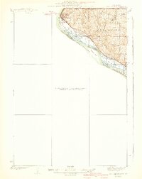
1940 Map of East Dubuque
USGS Topo · Published 1940About this map
The Mississippi River creates a dynamic western boundary for Jo Daviess County in this 1940 edition, featuring a complex network of islands and waterways like Ninemile Island and the Menominee Slough. The industrial and transit character of East Dubuque is clearly defined by the heavy rail presence of the Chicago Burlington and Quincy and the Illinois Central railroads, which hug the riverbank before heading inland. To the east, the rural landscape of Menominee township is dotted with traditional country schools, including Miller Sch, White Sch, and Ridge Sch, serving the upland farming communities. The map captures a specific era of infrastructure, showing the critical junction where rail lines met the river trade, while also marking the Illinois-Wisconsin Boundary Line at the northern edge of the quadrangle.
Find a feature on this map
20 named features on this map. Tap any name to fly to it.
Don’t see what you’re looking for? This feature index may not catch every label — zoom into the map to look around manually.
Map Details
Editions of this 1940 East Dubuque Map
3 editions found

Other maps of this area

1891 · Maquoketa
USGS Topo · 1:62,500

1891 · Baldwin
USGS Topo · 1:62,500

1900 · Lancaster
USGS Topo · 1:125,000

1901 · Peosta
USGS Topo · 1:125,000

1902 · Mineral Point
USGS Topo · 1:125,000

1904 · Lancaster
USGS Topo · 1:125,000

1908 · Lancaster
USGS Topo · 1:125,000

1911 · Galena
USGS Topo · 1:62,500

1913 · Galena
USGS Topo · 1:62,500

1935 · East Dubuque
USGS Topo · 1:62,500