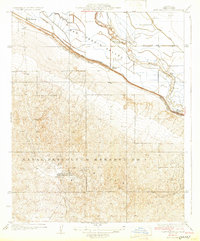
1932 Map of East Elk Hills
USGS Topo · Published 1932About this map
Naval Petroleum Reserve No 1 dominates the southern landscape of this 1932 survey, reflecting the intensive energy development of the Elk Hills region during the interwar years. The terrain is sharply divided between the industrial petroleum uplands and the agricultural floor of the San Joaquin Valley to the north. A sophisticated network of water management features, including the Eightyfoot Ditch, West Side Canal, and the Main Drain, illustrates the transformation of the arid valley floor into managed ranch land. Cultural landmarks such as the Indian Burial Mound near the valley edge suggest a deep history of human occupation prior to the arrival of modern irrigation and industry. The presence of the Standard Oil Co Hay-Carmen Camp and various ranches like Poplar Grove Ranch and Old Headquarters Ranch highlights the dual economy of oil extraction and livestock that defined Kern County's growth in this era.
Find a feature on this map
15 named features on this map. Tap any name to fly to it.
Don’t see what you’re looking for? This feature index may not catch every label — zoom into the map to look around manually.
Map Details
Editions of this 1932 East Elk Hills Map
2 editions found
Other maps of this area

1910 · Buena Vista Lake
USGS Topo · 1:125,000

1912 · McKittrick
USGS Topo · 1:125,000

1912 · Buena Vista Lake
USGS Topo · 1:125,000

1929 · Coles Levee
USGS Topo · 1:31,680

1929 · Mouth of Kern
USGS Topo · 1:31,680

1931 · Rio Bravo
USGS Topo · 1:31,680

1931 · Lokern
USGS Topo · 1:31,680

1932 · West Elk Hills
USGS Topo · 1:31,680

1932 · East Elk Hills
USGS Topo · 1:31,680

1932 · Mouth of Kern
USGS Topo · 1:31,680