
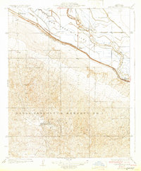
1932 Map of East Elk Hills
USGS Topo · Published 1932About this map
The Naval Petroleum Reserve No 1 dominates the southern landscape of this Kern County survey, reflecting the early 20th-century strategic importance of California’s oil resources. This industrial footprint is anchored by the Standard Oil Co Hay-Carman Camp, situated amidst the undulating contours of the Elk Hills. The map captures a critical transition where the high ground of the oil fields meets the intensive hydraulic engineering of the San Joaquin Valley floor.
Find a feature on this map
14 named features on this map. Tap any name to fly to it.
Don’t see what you’re looking for? This feature index may not catch every label — zoom into the map to look around manually.
Map Details
Editions of this 1932 East Elk Hills Map
2 editions found
Other maps of this area

1910 · Buena Vista Lake
USGS Topo · 1:125,000

1912 · McKittrick
USGS Topo · 1:125,000

1912 · Buena Vista Lake
USGS Topo · 1:125,000

1929 · Coles Levee
USGS Topo · 1:31,680

1929 · Mouth of Kern
USGS Topo · 1:31,680

1931 · Rio Bravo
USGS Topo · 1:31,680

1931 · Lokern
USGS Topo · 1:31,680

1932 · West Elk Hills
USGS Topo · 1:31,680

1932 · Mouth of Kern
USGS Topo · 1:31,680
1932 · Buttonwillow
USGS Topo · 1:31,680