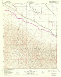
1954 Map of East Elk Hills
USGS Topo · Published 1976About this map
Naval Petroleum Reserve No 1 dominates this landscape in the western San Joaquin Valley, where oil production and water management define the terrain. The infrastructure of the petroleum industry is densely mapped throughout the Elk Hills, including the 35-R Gas Plant, the 3-G Gas Plant, and numerous oil wells and tanks. This 1954 survey, later updated to show the California Aqueduct in purple, illustrates the massive engineering efforts required to sustain agriculture and energy extraction in this arid environment.
Find a feature on this map
31 named features on this map. Tap any name to fly to it.
Don’t see what you’re looking for? This feature index may not catch every label — zoom into the map to look around manually.
Map Details
Editions of this 1954 East Elk Hills Map
4 editions found
Other maps of this area

1910 · Buena Vista Lake
USGS Topo · 1:125,000

1912 · McKittrick
USGS Topo · 1:125,000

1912 · Buena Vista Lake
USGS Topo · 1:125,000

1929 · Coles Levee
USGS Topo · 1:31,680

1929 · Mouth of Kern
USGS Topo · 1:31,680

1931 · Rio Bravo
USGS Topo · 1:31,680

1931 · Lokern
USGS Topo · 1:31,680

1932 · West Elk Hills
USGS Topo · 1:31,680

1932 · East Elk Hills
USGS Topo · 1:31,680

1932 · Mouth of Kern
USGS Topo · 1:31,680